
Sculpted tree on the Sevier Plateau

Mike at Thunder Mtn trail

Greg at Thunder Mountain Trail

The other Greg on the race,Greg Bach caught up with us and passed us on the Sevier Plateau

Bonsai on the Pink Cliffs

Virgin River Canyons

Singletrack on way to Pink Cliffs

I had just heard of the Dixie 311 from Scott Morris and then Mike Curiak invited me to tour it, not race it, The route looked fascinating. The route is a loop in the Dixie National Forest near Zion National Park and Cedar Breaks National Monument and also taking in the Fishook National Forest and the Tushar Mountains. Views on Google Earth where I could see the trail going on a rim above the Virgin River really sealed the deal, I had to do this ride. Joan got interested too which made it even better. She was willing to meet me periodically to get my feed bag replenished.Joan met me 2 times during the week. The fresh meals, resupply and Joan's company were magic.
Joan
I went with my sleeping gear on the bike and a couple of days of chow. The route went some places far from any resupply options. Mike and Greg who joined us were well stocked with freeze dry food.
Joan

I went with my sleeping gear on the bike and a couple of days of chow. The route went some places far from any resupply options. Mike and Greg who joined us were well stocked with freeze dry food.
The ride began in a peculiar way. I was all ramped up to go, I had done tons of preparation having been known as the slow poke on some previous rides. I was trying to repair my reputation. I waited round for quite a while but I was getting cold so decided to ride ahead and let them catch up to me. They did, but in a strange way I had set the stage for the rest of the week. I ended up riding by myself much of the time while Mike and Greg stopped more than I to take photos.Mike and Greg took a few pictures


The nights were pretty good with my well refined bike packing setup

I usually sleep from sundown to sunup so we ended up travelling at about the same average.

I usually sleep from sundown to sunup so we ended up travelling at about the same average.
I would catch Mike and Greg or they catch me and once we actually camped in the same place. We also shared a wonderful afternoon on a bluff on the Pink Cliffs where we took luxurious naps waking to the worlds best view. The trail kept to the Pink Cliffs along the tops and then plummeted down and rode more Pink Cliffs along the bottom.
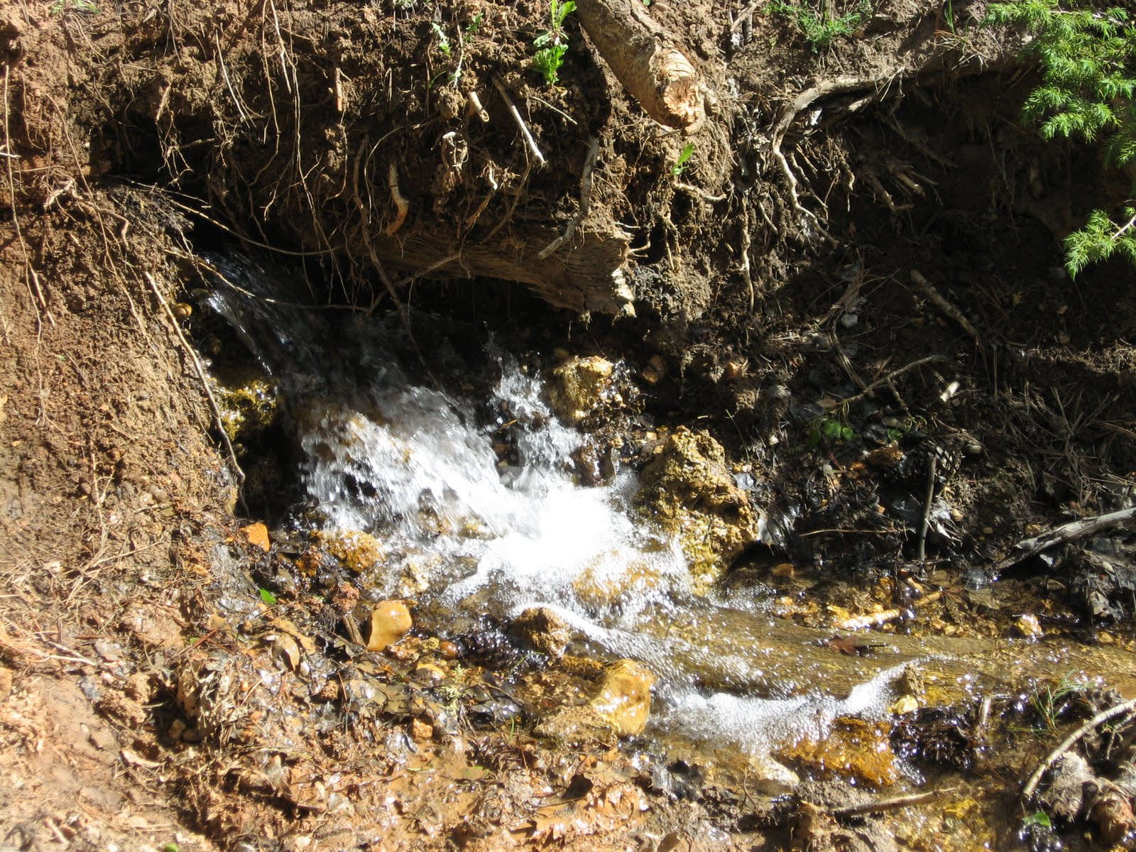
very welcome bubbling water after descending Pink Cliffs


 There was some hike-a-bike on the Dixie 311
Then the route climbed back into pine forests and lakes and aspen glades. I met Joan a couple of days out at Red Rock Canyon. She had all sorts of groceries waiting for us. Mike and Greg turned down the banquet and rode on into the afternoon. Even though we were "touring" Mike and Greg were not accepting support which could have technically kept them in the race. I was not racing so stayed and enjoyed the time with Joan and the next day continued the ride. There was a sweet lonely valley called Hunt where I scared up a bull elk who was bedded down near the trail.
There were miles of trail littered with downed trees. Sometimes it was a mile an hour or less dragging my bike over that deadfall. Other times I was merrily riding up a clear trail looking at the babbling brook on one side and the lupine and paintbrush on the other. It was all new country for me and the adventure was real.There were some trees down across many sections of trail

There was Adams Head looming above,
after many hours of climbing I circumnavigated Adams Head and passed near a point which showed on my GPS a place where presumably due to the grand view John W Powell had left a survey point to refer to.

 There was some hike-a-bike on the Dixie 311
Then the route climbed back into pine forests and lakes and aspen glades. I met Joan a couple of days out at Red Rock Canyon. She had all sorts of groceries waiting for us. Mike and Greg turned down the banquet and rode on into the afternoon. Even though we were "touring" Mike and Greg were not accepting support which could have technically kept them in the race. I was not racing so stayed and enjoyed the time with Joan and the next day continued the ride. There was a sweet lonely valley called Hunt where I scared up a bull elk who was bedded down near the trail.

There were miles of trail littered with downed trees. Sometimes it was a mile an hour or less dragging my bike over that deadfall. Other times I was merrily riding up a clear trail looking at the babbling brook on one side and the lupine and paintbrush on the other. It was all new country for me and the adventure was real.There were some trees down across many sections of trail

There was Adams Head looming above,

after many hours of climbing I circumnavigated Adams Head and passed near a point which showed on my GPS a place where presumably due to the grand view John W Powell had left a survey point to refer to.
There was a fun descent to Circleville and the cafe and resupply awaited. The visit to Circleville was brief and then the great climb into the Tushar's commenced.
Tushar Mountains

Paiute ATV trail in Tushar Mountains

Road out of Circleville climbing into Tushar Mountains

Old Boiler on a rather trying section of nearly non-existent trail but seeing the secret valley and the boiler was worth it
 Crossing Hwy 20 in Buckskin Valley
A few days later after getting a look at the snow capped Tushar mountains and just kissing the snowbanks I descended to a place where I was going to meet Joan.


As soon as I arrived I knew our plan was in trouble. The road which she was to have come up was too rough for our car. I did not know where she was. There was no cell phone service it was getting late in the day and I was out of supplies. The solution to this conundrum was to plummet to the valley and ride to the town of Parowan. I went to the nearest cafe, ordered a steak and pondered my next move as the sun set. In the end I stayed in a motel, Joan camped in the mountains and we reunited the next day. Joan had a good night camping, I had a worried night in the motel trying to think if I could do something . That was it for my ride. I was tired, I'd had a good run. For me it was the Dixie 270.
Mike and Greg finished all 311 miles, Joan and I motor toured Cedar Breaks and Capitol Reef National Park and then we headed back to Leadville. Ahh, the home bed feels mighty good after sleeping on the ground.
What a route, what a ride. Thanks to Dave and Linda for the route planning, thanks to Mike, Scott, Greg for getting me informed and motivated to do this ride, and thanks to Joan for encouraging and supporting me.

3 comments:
Thanks for the story and pictures Lee. It really looks like you appreciated the remote, seldom seen areas. Great pictures too! Bonsai trees and sculpted trees...good stuff.
Great write up Lee. It's always fun to look at pictures and say, "I know where he took that"!
It was fun meeting you after reading about you for several years.
Later,
Dave
PS Harris, did you go to Waterton canyon just to watch the construction?
Good stuff, Lee. Enjoyed the read.
Post a Comment